Solutions

CARTO

Optimize your territorial expansion and urban planning with high-level analysis tools.
Advanced Spatial Analytics
Geospatial analysis platform for exploiting large volumes of location data.

Advanced spatial analysis
Datos geográficos convertidos en decisiones

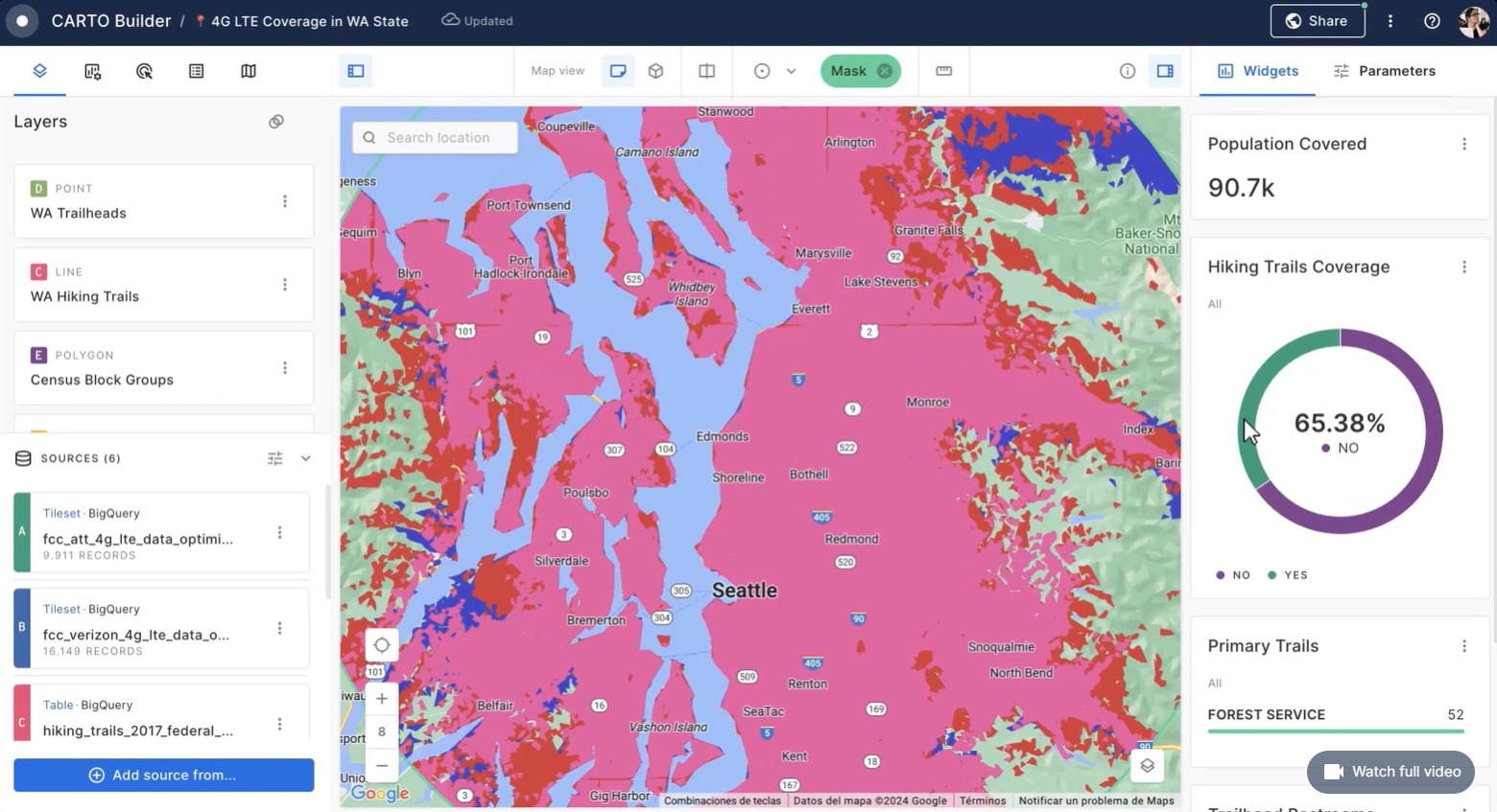
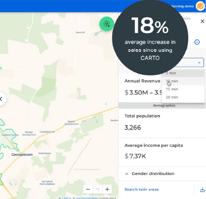
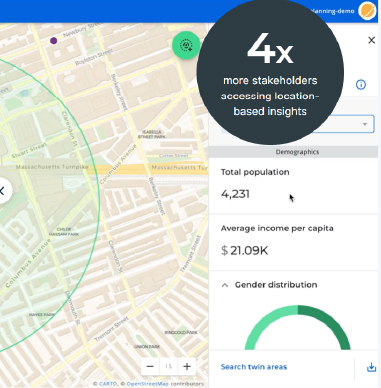
Predict performance, don't just monitor it

Go beyond simple BI sales maps by store and use our sophisticated analytical models to predict where the next big opportunity will be for your physical operations, considering recent consumer behavior.— Combine your existing internal data with external data flows to predict revenues at new or existing sites, using data such as foot traffic, credit card transactions, and weather.— Share information about expected store performance in an intuitive solution that non-technical teams find it easy to use, whether it's real estate, operations, strategy, or marketing.

Identify white space you couldn't see before

— Your “instinct” can't always tell you where the next big opportunity is, but our whitespace analysis can, avoiding cannibalization and ensuring omnichannel efficiencies. — Visualize commercial/store pickup areas to understand where your key customer segments are in relation to your store network and competitive locations.— Identify key target locations for expansion, in existing or new territories (using our Global Spatial Data Catalog to drive your decisions).

Identify the opportunities your competitors are missing

As consumer behavior changes faster than ever, retailers can no longer rely on outdated census data to make decisions, especially after a pandemic. The CARTO repository of more than 12,000 data sets ensures that you are on the pulse, whether they are points of interest, opinions on social networks; traffic data or demographic data.— Visualize your assets in relation to competitors, making sure to identify new trends and opportunities before others.— Avoid making costly mistakes in site selection, saving millions of dollars in the process.

Prediga el rendimiento, no se limite a supervisarlo

Vaya más allá de los simples mapas de BIde ventas por tienda y utilice nuestros sofisticados modelos analíticos para predecir dónde estará la próxima gran oportunidad para sus operaciones físicas, considerando el comportamiento reciente del consumidor.— Combine sus datos internos existentes con flujos de datos externos para predecir los ingresos en sitios nuevos o existentes, utilizando datos como el tráfico peatonal, las transacciones con tarjetas de crédito y el clima.— Comparta información sobre el rendimiento previsto de la tienda en una solución intuitiva que los equipos no técnicos encuentran fácil de usar, ya sea bienes raíces, operaciones, estrategia o marketing.

Identifique el espacio en blanco que no podía ver antes

— Su «instinto» no siempre puede decirledónde está la próxima gran oportunidad,pero nuestro análisis de espacios en blanco sípuede, evitando la canibalización ygarantizando eficiencias omnicanal.— Visualice las áreas comerciales/decaptación de tiendas para comprenderdónde están sus segmentos clave de clientesen relación con su red de tiendas y lasubicaciones de la competencia.— Identifique ubicaciones objetivo clave parala expansión, en territorios existentes onuevos (utilizando nuestro Catálogo de datosespaciales global para impulsar susdecisiones).

Identifique las oportunidades que sus competidores están perdiendo

Dado que el comportamiento de losconsumidores cambia más rápido quenunca, los minoristas ya no puedendepender de datos censales obsoletos paratomar decisiones, especialmente después deuna pandemia. El repositorio de CARTO demás de 12.000 conjuntos de datos legarantiza estar al tanto del pulso, ya seanpuntos de interés, opiniones en las redessociales; datos de tráfico o datosdemográficos.— Visualice sus activos en relación con loscompetidores, asegurándose de identificarnuevas tendencias y oportunidades antesque otros.— Evite cometer errores costosos en laselección del sitio, ahorrando millones dedólares en el proceso.
Geographic modeling
Crossing business data with location.
Advanced Visualization
Interactive maps and dashboards.
Coverage analysis
Evaluation of territories and networks.
Support for smart cities
Data for urban planning.
Territorial intelligence
CARTO allows us to understand patterns, risks and geographical opportunities.
An ecosystem of partners and customers World-class
Are you ready to start?
Start your free trial today.
Request demo